

TRANSPORTATION AND CORRIDORS
Latest version.
- ContentsIntroduction 321Objective 1: Reduce the Impact on the Natural Environment 322Objective 2: Improve Circulation and Accessibility 323Objective 3: Reduce Congestion 329Objective 4: Improve Character and Sense of Community Along Corridors 309Objective 5: Improve and Maintain the Condition of Existing 331Transportation and Corridors Benchmarks 331TRANSPORTATION AND CORRIDORSLabeled the "Crossroads of America" Lake County has been experiencing increasing volumes of vehicular traffic, particularly on the county roads in developing areas. The increasing demands placed on the current transportation system have resulted in a number of problems. To address these concerns, the county must examine the broad issue of transportation, circulation and access, in its broadest definition, and develop an integrated program which includes public transportation, recreational opportunities, and corridor enhancement.The overall mission of the transportation programs is to improve accessibility and circulation patterns through Lake County, while minimizing the community, environmental, and social impacts that may result. This section of the Comprehensive Plan examines Lake County's transportation routes from a county-wide, regional perspective. In other words, unincorporated Lake County is not the sole focus of this section. The reason for this broader perspective is based principally on the realization that many of unincorporated Lake County's main thoroughfares also pass through independent municipalities. Thus, the transportation recommendations attempt to place unincorporated Lake County in the larger regional context. Programs for improving the Lake County's transportation system are based on the objectives of:• reducing the impact on the natural environment;• improving circulation and accessibility;• improving character and sense of community along corridors;• reducing congestion; and• improving and maintaining the condition of existing roadsIntersection of I-65 and U.S. 30
 Objective One: Reduce the Impact on the Natural EnvironmentAction Step 1Increase incentives to those persons who utilize rideshare programs (such as reducing toll rates on toll roads to higher occupancy vehicles, creating park and ride areas at major intersections along U.S. 41 and 1-65, and creating high occupancy vehicle lanes).Action Step 2Develop new limited access corridors between targeted residential, industrial, and commercial growth areas.Action Step 3Educate residents on ways to limit auto emissions (maintain pollution equipment, frequent tune-ups, align wheels, properly inflate tires, and car pool).Action Step 4Increase roadside vegetation and sign ordinances to improve the aesthetic environment of the county and improve sense of community and character between municipalities.Action Step 5Preserve and develop abandoned or natural corridors into separate bikeways to encourage bicycle use, discourage automobile travel, and reduce the impact on the environment. Some potential sites include....• Erie Lackawana Railroad Corridor - Little Calumet River to Crown Point to Lomax (41 miles);• Penn Central Railroad Corridor - Schererville to Crown Point to Hebron (25 miles);• Chesapeake & Ohio Railroad Corridor - Merrillville to Malden in Porter County (25 miles);• Kankakee River Wide Levees - Illinois State Line to LaPorte/Starke County Line (60 miles); and• Little Calumet River Levees - Illinois State Line to Martin Luther King Drive (20 miles).
 Objective Two: Improve Circulation and AccessibilityAction Step 1Encourage the establishment of interlocal agreements and joint planning for highways between Lake County and its cities and towns as well as with adjacent counties. Such coordination is essential where corridors overlap both unincorporated Lake County and independent municipalities (for example, 109th Avenue which runs east-west through Crown Point and Winfield).Action Step 2Create/enhance East/West links within Lake County.• upgrade 181st Avenue west of U.S. 41, link to Will County, Illinois;• complete and improve 129th Avenue from Marshall Street east to Winfield, including bridge over 1-65;• upgrade/extend 153.rd Avenue corridor;• upgrade 109th Avenue from Broadway east through Winfield; obtain additional right-of-way in Winfield for future widening to three lanes;• extend 133rd Avenue from State Route 55 east to Delaware Street;• extend 53rd Avenue east to Taft Street;• upgrade 101st Avenue from Crown Point to Winfield, including new cloverleaf intersection at I-65.Action Step 3Develop a direct route from southern Lake County into Illinois.• extend/improve 109th Avenue westward into Illinois;• construct a limited access expressway linking 1-394 in Illinois with Porter County or upgrade existing state/county roads within the east-west corridor.Action Step 4Reduce traffic congestion in Lowell.• connect county roads 169th, 171st, 173rd north of Lowell;• utilize Belshaw Avenue as a bypass, link Clark Street to bypass;• create a left turn lane on Indiana 2 in Lowell.Action Step 5Coordinate abandoned rail corridors as part of the existing Bikeway Network of Northwest Indiana and link with other Lake County recreational opportunities and Land-Use Target Areas.
 Action Step 6Improve existing North/South roads in the vicinity of St. John and Illinois.• pave and improve Marquette Street just outside of St. John;• upgrade White Oak Avenue north of 109th;• improve Cline Avenue north of State Route 8 (231);• improve Calumet Avenue north of 109th.Action Step 7Improve more heavily traveled roads to include a "Class II type" bikeway (bike lane) or a "Class I" (separated bikeway) such as adjacent/abandoned rail corridors.Action Step 8Coordinate a region-wide bus service that is accessible to all major cities and towns. Some of the participants in the system will include....• Gary Public Transportation Corporation, with connecting routes in Gary, East Chicago, and Hammond;• East Chicago Bus Transit, neighborhood routes that connect with commercial, medical, and service facilities throughout East Chicago, including steel mills;• Hammond Transit System, connect with Pace and CTA in Illinois;• Hammond Yellow Coach Lines, provide taxi service to almost every city and town in Lake County;• Tri-State Coaches, provide airport bus services from Midway/O'Hare to Hammond, Gary, and Merrillville.Action Step 9Coordinate bikeways and other transportation methods with transfer stations in existing communities, new subdivisions, and new Land-Use Target Areas, encourage sidewalks and bike paths in new subdivisions.Action Step 10Begin commuter rail service on the Amtrak Line with the location of rail stations in Valpraiso, Hobart, and Gary and the old Seaboard System with stations in Lowell, St. John, and Dyer.Proposed Corridor Enhancements
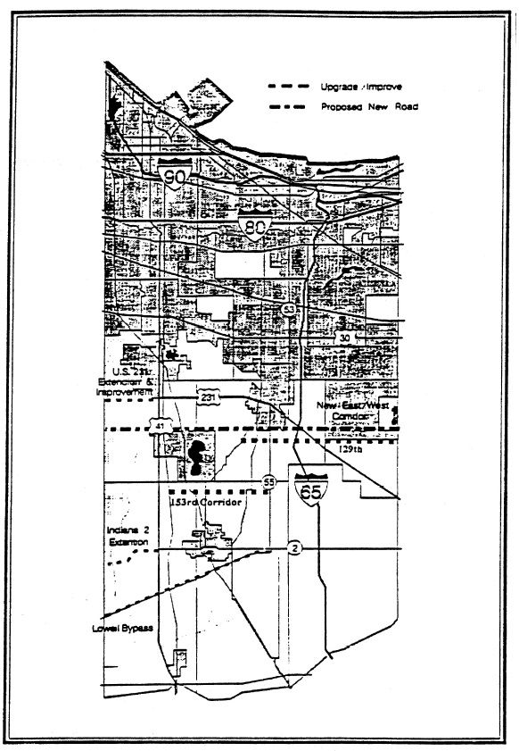
 Objective Three: Reduce CongestionAction Step 1Improve at-grade railroad crossings or convert to over- and underpasses where feasible to encourage high speed rail transit and reduce congestion. Trouble locations include....• Conrail Rail Corridor running north/south through Schneider and Schererville and east/west through Schneider;• Seaboard System Rail corridor running through Lowell, St. John, and Dyer;• Grand Trunk Western Railroad corridor running parallel with U.S. 30.Action Step 2Utilize synchronized lights, eliminate access points (curb cuts), expand use of frontage roads, limit left turns, designate truck routes, and reduce toll rates.• improve and signalize the intersection of 109th and Randolph in Winfield.Action Step 3Upgrade county roads based on designated Land-Use Target Areas to accommodate future growth before congestion occurs.Objective Four: Improve Character and Sense of Community Along CorridorsAction Step 1Use design review ordinances to encourage consistent design.Action Step 2Use signage, landscaping, and icons to identify the entrance to a county, township, community, or district.Action Step 3Increase roadside vegetation and sign ordinances to improve the aesthetic environment of the county and improve sense of character in municipalities. Plans should include elements of• signage • pedestrian setbacks• vehicular access • vegetation buffersIntersection of U.S. 41 and SR 2
 Vehicular AccessTypical Lake County Access Standards
 Proposed Access Designs
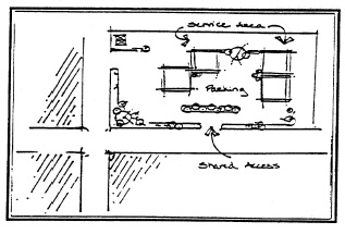 Objective Five: Improve and Maintain the Condition of Existing RoadsAction Step 1Review and revise the functional classification system for roads based on changes in land use development, traffic volumes, and roadway design in order to obtain additional state and/or federal funding for roadway improvements. This action step would require an up to date inventory of existing roadway conditions throughout Lake County keeping in mind the effects that continued urbanization, population growth and changing commuting patterns have had on the road system. In particular, formerly rural roads which now handle more suburban or urban commuter traffic need serious attention.Action Step 2Establish an adequate public facilities ordinance for county roads requiring the developer to make any improvements necessary to match the deficit in roadway capacity or condition that would be caused by the new development. This ordinance could be for all types of development or just specific categories of development (for example, any developments which generate substantial heavy truck traffic).Action Step 3Establish transportation impact fees which would require developers to contribute their fair share for roadway improvements that would be needed for their development. Zone improvement districts would have to be established, and amendments to the zoning ordinance would have to be done to meet the requirements of the Indiana enabling legislation for impact fees.Transportation and Corridors BenchmarksBus Service
 Establish a roundtable discussion of all local and regional service providers to explore additional/coordinated service in unincorporated areas. Establish connecting routes in Gary, Hammond, East Chicago, and Highland. Institute county-wide bus service with connecting routes to Crown Point, Merrillville, Lowell, Cedar Lake, St. John, Schererville, Dyer, Griffith, Hobart, and new Land-Use Target Areas.Existing Bikeways Form a regional bicycle club of enthusiasts to promote the use of routes. Increase signage and bicycle orientated services (i.e., benches, water fountains) on existing routes. Establish a priority list of current routes to be upgraded to separate bicycle lanes. Coordinate bikeways with other transit methods by establishing bicycle lockers at railroad stations and bus terminals.Proposed Bikeways Form greenway organizations of interested citizens, bicycle clubs, business leaders, and elected officials Acquisition of abandoned rail corridors by county or non-profit bikeway development agency/committee. Link new routes with existing bikeways, rail stations, bus terminals, and new Land-Use Target Areas.Transportation and Corridors BenchmarksRailroads Improved at-grade crossings on all state and U.S. highways. Institution of commuter rail service on the Amtrack and Seaboard lines. Establishment of new, or rehabilitated rail stations at Lowell, Cedar Lake, St. John, and Dyer.Automobile Traffic Annually measure and incrementally reduce automobile emissions. Maintain or reduce current levels of Average Annual Daily Traffic. Increase the number, capacity of roads while reducing county expenditure through public/private partnerships. Develop a direct access road to Illinois in the southern portion of the county. Develop a north-south route through Winfield Township. Establish a county-wide truck route plan. Adopt an adequate public facilities ordinance or impact fees for roadway improvements needed as a result of new development. Obtain an up to date inventory of county-wide roadway conditions to be used in the revision of the functional classification system for roads.(Prior Code, Comprehensive Plan)